


The Beaver & Erie Canal, also known as the Erie Extension Canal, was proposed as early as 1822 as a way to connect the industries of Pittsburgh, Pennsylvania, with the shipping network centered at Lake Erie. It was designed to be part of the larger Pennsylvania Canal System, which included the Main Line of Public Works – a canal/railroad route connecting Philadelphia to Pittsburgh. The state government in Harrisburg also came to see the new canal as a business rival to the Erie Canal, which opened in 1825 and allowed profitable access from New York City to Albany via the Hudson River and then onto Lake Erie via the 363-mile canal.
After a decade of negotiations, surveying, and planning the construction finally got underway in 1831 on the sixty-one-mile-long Beaver Division of the Beaver & Erie Canal, the southernmost of the three sections or “divisions” of the canal. The Beaver Division’s southern terminus started at the Ohio River at Rochester, traveled north along the east bank of the Beaver River through the New Brighton area, crossed over the mouth of the Connoquenessing Creek at Rock Point, continued on past Chewton and Old Moravia (now West Pittsburg) onto Mahoningtown, followed the east bank of the Shenango River up into downtown New Castle, and then crossed over the mouth of the Neshannock Creek and traveled northwest along the eastern bank of the Shenango River up to Pulaski. From Pulaski the Shenango Division, connecting Pulaski to Conneaut Lake, and then the Conneaut Division, reaching Lake Erie, later extended the canal a total of 136 miles.
The Beaver Division was opened for business up to the Western Reserve Harbor (now Harbor Bridge or simply Harbor), about five miles west of New Castle, by late 1833. “The Harbor” was a thriving settlement in those days as wagons lined up to unload the freight boats and continue on to the west. The canal project stalled for some time and the state sold the venture to the Erie Canal Company, which completed and opened the remaining route to Lake Erie by 1844. To pay for the venture tolls were collected from the boat captains at several locations including New Brighton, Mahoningtown, and downtown New Castle.
Hundreds of wooden shallow-draft “packet boats” and “line boats” plied the canal day and night carrying their lucrative freight and passengers. The boats, pulled by a small team of horses or mules on an adjoining towpath, were narrow but some were up to ninety-feet in length. The more expensive packet boats were primarily for passenger service and contained quarters for the crew and the horses, and a large multi-purpose cabin/dining/sleeping area for up to the eighty passengers. Though conditions were primitive by today’s standards the canal boats were a huge advancement in travel over the old stagecoach system. The slower moving line boats primarily hauled freight such as coal and pig iron, but also a limited number of passengers at a cheaper rate. Speed as not of the essence and a typical journey from Rochester to New Castle took about twelve hours.
In most places the undersized canal bed was typical of the day with a narrow width and a depth of only about five feet. The Beaver Division featured a total of seventeen locks and six “slackwater dams” that helped the small boats navigate around and through areas of sudden elevation and also treacherous rapids. There was no long, continuous canal as the boats often took to the river(s) at various locations where slackwater areas (level and calm stretches of water created by a dam) were available. Seven locks helped the boats navigate the various rapids in the modern day New Brighton-Beaver Falls area (Locks No. 9-15) while others were located at Rock Point (No. 8), Staylesville (No. 7), Moravia (No. 4-6), Mahoningtown (No. 3), and New Castle (No. 1-2). An aqueduct, made on stone piers and a wooden and iron bed, carried the canal as it crossed over the deep gorge at the mouth of the Big Run near Gardner Avenue in New Castle. Additionally, at Rock Point, the horses were brought aboard as the boats were guided by the crew across the deep waters of the mouth of the Connoquenessing Creek. This was also the procedure when the boats took to the slackwater areas.
All along the route small settlements known as “canal towns,” some already existing and others just springing to life, flourished due to the trade and visitors the waterway brought. Among the towns or areas that benefited were New Brighton, Rock Point, Chewton, Staylesville (or Hardscrabble), Old Moravia, Mahoningtown, New Castle, Harbor Bridge, Pulaski, and West Middlesex. In New Castle the boats would veer off onto the Neshannock Creek, aided by a dam and a lock, and load/unload freight and passengers at the wharf located where the New Castle Dry Goods building now sits. New Castle in particular thrived because of the canal trade, enough so that the town was able to become the seat of the new Lawrence County when that entity was carved from the counties of Beaver and Mercer in 1848. Mahoningtown also served as the eastern terminus of the Pennsylvania & Ohio Canal (the so-called Cross-Cut Canal), a waterway that opened along the Mahoning River in 1838 and connected the Beaver & Erie Canal to the distant Ohio & Erie Canal.
The area of Rock Point, where the Matheny Inn (or Tavern) was built in 1836, in particular is steeped in the romantic history of the “old ditch.” Among the famous people known to have passed through the area on canal boats include iconic English writer Charles Dickens (1812-1870), American adventurist and author James Fenimore Cooper (1789-1851), and U.S. President Zachary Taylor (1784-1850). The most famous story involves a poor teenaged boat crewman from Ohio named James A. Garfield, who fell off the “Evening Star” packet boat one night in 1847 at Rock Point and nearly drowned. He was taken in at the Matheny Inn for the night and soon gave up any thoughts of a “seagoing” career. He later worked as a carpenter and attended college, rose up through the ranks of the Union Army during the American Civil War, served nine terms as a U.S. Congressman, and was elected as the Twentieth U.S. President in 1880. Garfield’s term was short lived as he was assassinated in office in September 1881.
The canal flourished for several decades but the coming of the railroads helped hasten its demise. Beginning in 1852 the Ohio & Pennsylvania Railroad (O&P), consolidated under the Pittsburgh, Fort Wayne, & Chicago Railroad Company (PFW&C) in 1856, was the first railroad to begin operating through Lawrence County. Other railroad lines followed in the coming years, including the Erie & Pittsburgh Railroad (E&P) that ran from New Castle to Erie and opened in 1864. The sharp decline in freight business signaled the demise of the canal and the Erie Canal Company went bankrupt in about 1870. The E&P, then under lease by the powerful Pennsylvania Railroad (PRR), purchased the canal and continued to operate it until an aqueduct over Elk Creek in Erie County collapsed in 1871. Afterwards, only the lower portion of the canal (below New Castle) remained in use for a few years. The locks, tollhouses, and equipment were sold off or put to use by the railroad.
Many folks believe the E&P had no intention to maintain the canal and the collapse of the aqueduct at Elk Creek – which was officially deemed too expensive to rebuild – was suspicious in nature. The level towpaths and filled-in canal beds would offer a natural right-a-way for railroad tracks and this made any existing canals desirable for takeover by the railroad companies. Before too long the PRR laid a narrow-gauge track along the lower stretches of the former canal for the Pittsburgh, Youngstown, and Ashtabula Railroad (PY&A), which ran north from Pittsburgh until it crossed over to the western bank of the Beaver River at Chewton-Wampum. The stone used to construct the piers for the PY&A bridge at Rock Point, which opened in 1874 and was rebuilt in 1903-04, were taken from the nearby Lock No. 8.
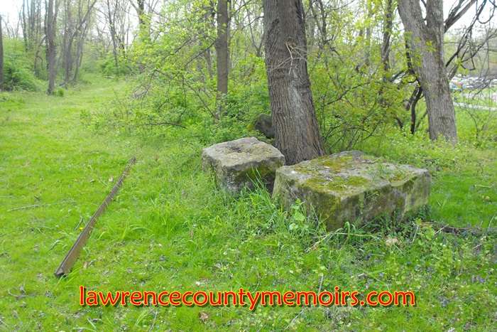
The closing of the canal also brought about the demise of various businesses such as the historic Matheny Inn at Rock Point, which closed due to a lack of patronage in 1872. In the coming years once thriving “canal towns” such as Old Moravia and Staylesville were literally abandoned and other locales returned to their sleepy roots. Not much remains of the old canal in Lawrence County but you can find traces of the old canal waterway at Rock Point, what remains of Lock No. 7 at Staylesville, parts of the canal bed and towpath are visible at several locations in West Pittsburg, and possibly the foundation of the old aqueduct (now supporting a railroad bridge) across Big Run in New Castle.
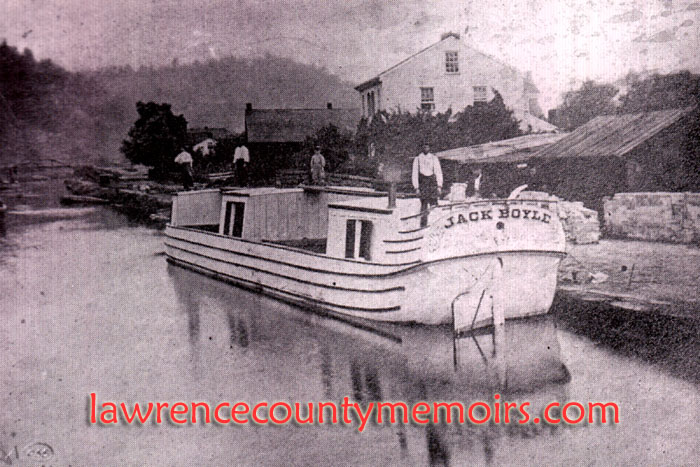 The small packet boat Jack Boyle, named after its owner/captain who resided in New Brighton, sits at rest along the Beaver & Erie Canal. Hundreds of these shallow-draft boats plied the canal during its heyday. (c1875) |
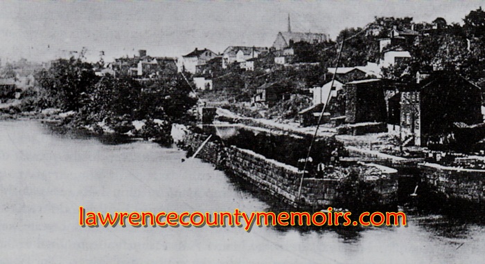
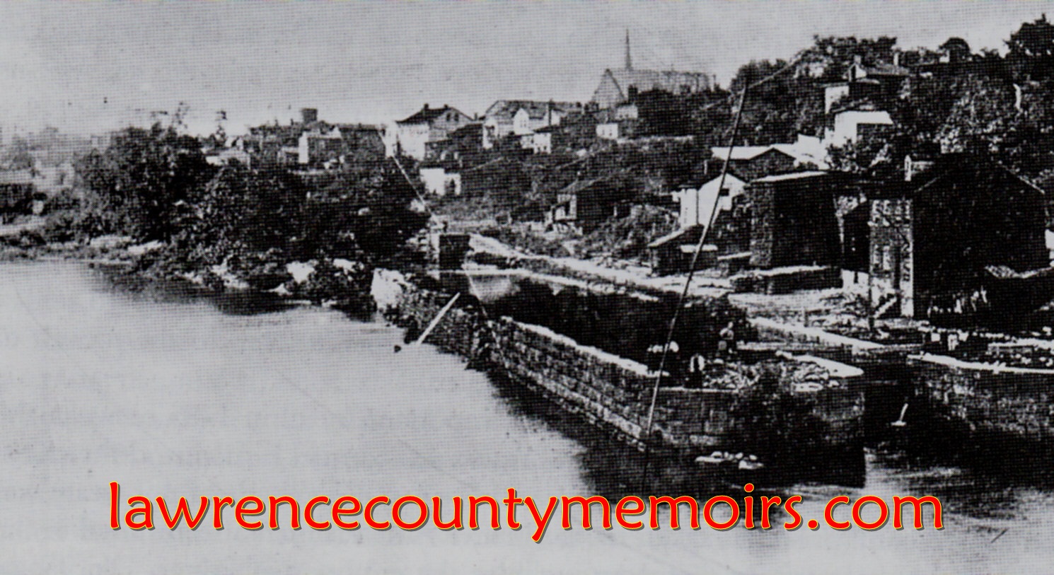
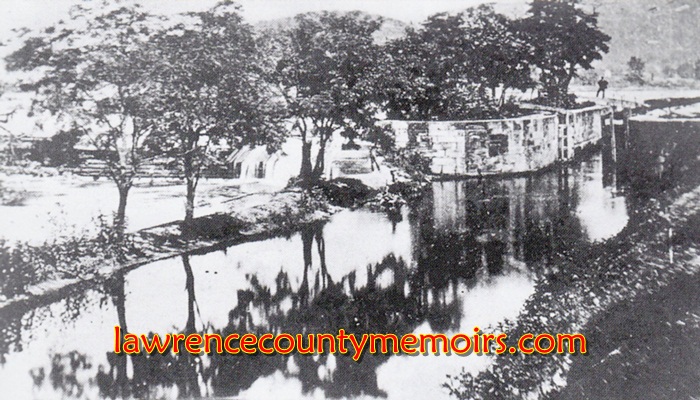 The canal lock just north of New Brighton near the old dam at the former Tenth Street Bridge. The canal ran along the east side of the Beaver River from Rochester to New Castle. (c1869) Full Size |
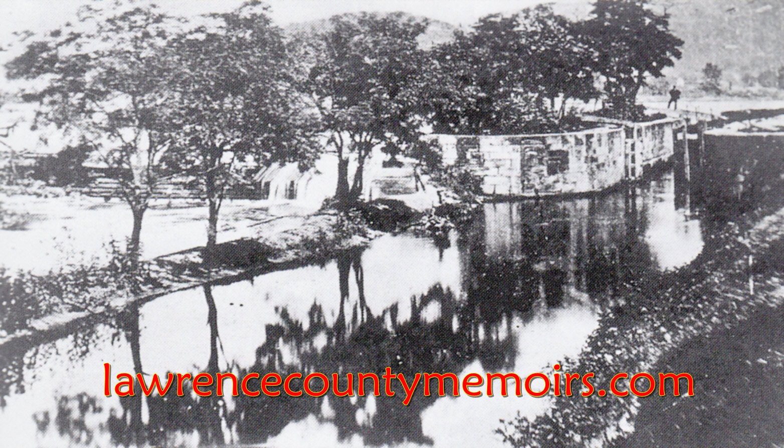
 One of the four canal locks that were situated in close proximity at New Brighton. (c1880) Full Size |
 Remnants of the former canal bed at what was the former village of Staylesville (or Hardscrabble), north of Chewton. (Apr 2012) |  Another view of the former canal bed at Staylesville. The village was tied to the canal and died after the waterway was abandoned in the early 1870’s. (Apr 2012) |
 Part of the former canal bed near the water plant in West Pittsburg. (Apr 2012) | 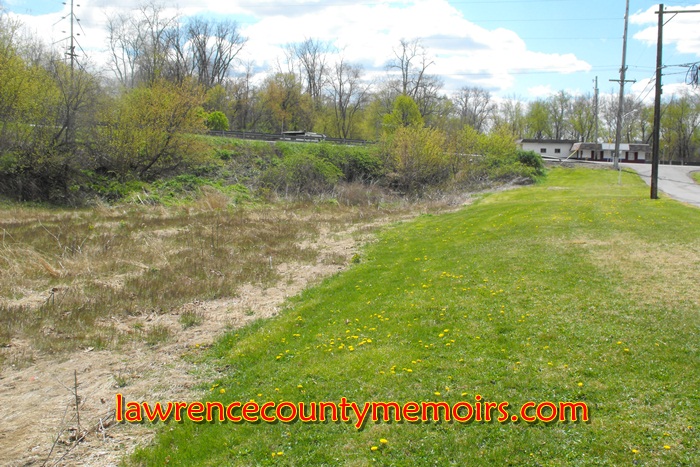 The canal bed is quite visible along Canal Street (off of Route 168) in West Pittsburg. This is my Uncle Charlie DeMarc’s property. (Apr 2012) |
 These appear to be stones from the canal, located along the former towpath near Galilee Road in West Pittsburg. (Apr 2012) | 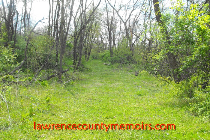 A great view of the former towpath of the canal located in West Pittsburg. Horses walked along this path while towing the packet boats in the canal (off photo to left). (Apr 2012) |
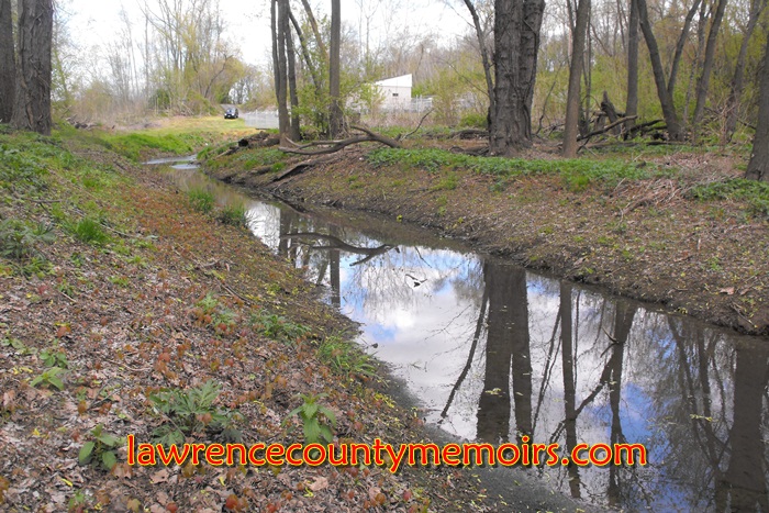
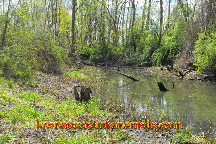 Water fills part of the former canal near Galilee Road in West Pittsburg. (Apr 2012) | 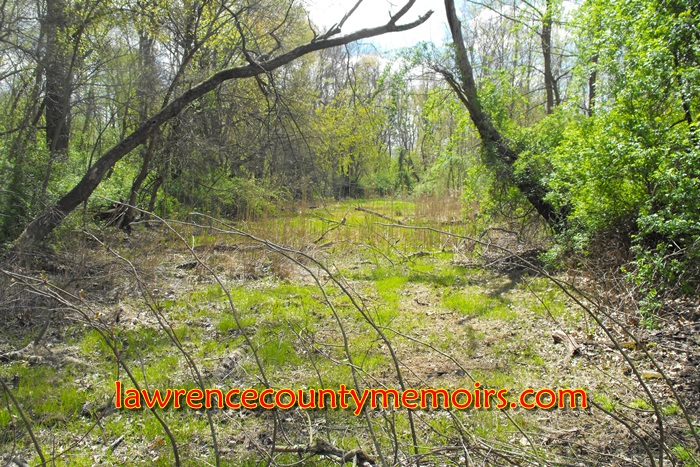 Another view of the towpath in West Pittsburg. (Apr 2012) |
Comments
Sam Mielke #
Uncle Charlie DeMarc? I spent a lot of time at the “junk yard”, bs’g with Charlie.
Jeff Bales Jr. #
(EDITOR’S NOTE) Sam, Charlie and my late grandfather George DeMarc, who died in a car accident in 1953, are brothers. Charlie is quite a guy! Jeff
Ken Wigton #
Jeff, this is solid gold and I can’t wait to read on. I am originally from New Castle/Edinburg which you referenced as Harbor Town. I must have crossed the Harbor Bridge thousands of times. I have a picture of the old covered bridge that preceded it. My great-grand uncle worked on those boats starting at age eleven per his biography. I visit once or twice a year as I still have relatives in both towns. Love this site and if there’s any way I can help you please let me know. I have deeds where my ancestors sold property to the railroads. My great grandfather lived right along the Cross-Cut canal and sold some of that land to the railroad that is still there today. Ken W.
Chet Blake Jr #
This is an absolutely great history piece for me. I grew up on River Road, knew your Uncle Charlie and even worked for him in the junk yard. Charlie offered me work when there was no unemployment benefits because the State went bust with all the companies laying off. Charlie has always been a good friend to me, my Dad and Uncles. I used to ice skate on the canal on Canal Street with the gang from the Burg. The gang word was a good thing then :-) What great memories. I miss the area greatly and plan on moving back after retirement possibly next year. Keep up the good work !
Bill Jackson #
Hey, this is great! My Grandfather, Robert B. Jackson Sr., took me down to the river below Chewton and told me about the canal, Hardscrabble and how the name came about. Glad to see you have documented this!
Ray Hall #
I’m planning on retracing the Pennsylvania and Ohio Canal route from Mahoningtown/New Castle all the way to Akron, Ohio and documenting my journey throw pictures and notes. I’m reaching out to locals, Historians and Historical Societies along the route for information regarding remnants/ruins/routes and contacts and would appreciate any help your society could offer. Thank you.
Deborah Polk #
David Morton Marshall, established Marshall Funeral Home and you talked about it on web site. Have more info on him and would like to add it on grave site. Where is it?
Comment